Circumnavigating Japan: A "True" Circumnavigation

Neither of the circumnavigation routes described in Parts 4 and 5 of this Japan Cruising Routes series is a "true" Japan circumnavigation that takes one on the outside of Japan's four (inhabited) cardinal points and of Japan's four main islands and then back to one's starting point. One has to go out of one's way to do that, which is what I did.
There are many ways to start a true Japan circumnavigation, but I approached Japan from Hawaii (37-day passage), clearing in at Hakodate. From there, I did a clockwise circumnavigation of Hokkaido (so going around Japan's northernmost and easternmost points) and then went south along the Sea of Japan coast to Fukuoka, where I left my boat for the winter.
In the following spring, I went down the west coast of Kyushu, did a non-stop, five-day passage from the Goto Islands to Yonaguni (Japan's westernmost point, near Taiwan), then to Hateruma (Japan's southernmost point). I then headed north through the Ryukyu Islands to Kyushu and Shikoku's southern coast and into the Seto Inland Sea, where I left my boat for the second winter.
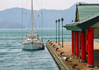
In the third year, I went up the Pacific coast to Hakodate to complete the circumnavigation. Afterward, I went back down the Sea of Japan coast for a second time and into the Seto Inland Sea (where I started living on an island in a classic Japanese farmhouse with a spectacular ocean view).
In the previous five parts of this Japan Cruising Routes series, I introduced noteworthy places for cruisers to include in their passage plans. In this part, I introduce some of the highlights and lowlights of my own circumnavigation.
Passage to Yonaguni
After over a year of coastal day passages, I was looking forward to having a relaxing 700NM offshore passage from Fukue at the southern end of the Goto Islands to Yonaguni, Japan's westernmost point. That "relaxing passage" started with my propeller getting badly snarled by a big ball of hondawara seaweed just a few hours after departing. It continued with steady 35-45 knot winds (broad reach or running, fortunately) and 3-4 meter waves, heavy rain and thick fog, hundreds of rust-bucket Chinese fishing boats (zig-zagging in packs of 20-30 at night and then anchoring in 200 meters during the day), and dozens of oil tankers and cargo ships. I was very glad to be able to "relax" after I reached Yonaguni in slightly less than five days (vs. my initial six-day estimate).

Hateruma
A day sail away from Yonaguni is the island of Hateruma, Japan's southernmost point. It's a lovely island, with expansive sugarcane fields, low-slung houses surrounded by high coral-rock walls to protect them from the many typhoons that sweep the island, and very friendly people.

Fog in Hokkaido
In eastern Hokkaido (as well as the northeast coast of Honshu), thick fog is a fact of life in the spring/summer...having even a boat length of visibility is considered "good." If one is afraid to sail in fog, one will be stuck in port for a very long time.
I once spent three consecutive days hugging the coast but never saw land. On the first day, heading to Nemuro in pea soup fog, I was carefully following the line separating Russia and Japan, laid down with waypoints given to me by the Coast Guard. On radar, I could see a Russian naval ship running parallel to me less than 50 meters away and I could hear its engine, but I couldn't catch even a glimpse of it for the three hours it tracked me
The next day, still in thick fog, I went between Russia-controlled Habomai Islands and Japan's Cape Nosappu, Japan's easternmost point. It's only two nautical miles between them but I never saw land or the lighthouses on either side. Approaching the fishing port of Kiritappu, which literally means "lots of fog," I had to pick my way through unseen fishing nets and was very relieved to find the lighthouse marking the harbour entrance.
On the third day, I could hear fishing boats zipping behind me, in front of me, and along side of me, but I never saw them. (Fortunately, Hokkaido fishing boats all seem to carry very sensitive radar systems and the captains really know how to use them.) After several hours, the fog gradually dissipated, being replaced by cold, drenching rain. I had never been so glad to get soaking wet!!

Suo Oshima
My life changed in more ways than one when I went to the island of Suo-Oshima (shown on charts as Yashiro Island) in the western part of the Seto Inland Sea. It started with a phone call. I always leave a note taped to my boat giving my name and telephone number, just in case I am moored in somebody's spot. On this day, shortly after arriving in Suo-Oshima, I hopped on my bicycle to go to the supermarket and the phone rang. The person at the other end said, "I guess you want to go to the local hot spring, but it's rather far away, so would you like to use my car?" I said yes, and so he left the car near my boat.
Later, after a relaxing bath, I was having dinner in the cockpit when he dropped by to say hello. He joined me for some beers, then we went to his home for some sake. The next day, we had dinner and more sake....the mayor joined us....and so on. We talked about my desire to find a place to live while writing a Japan Cruising Guide, and a few days later the mayor suggested that I live in Suo-Oshima. I replied that there was no place to moor my boat. Fast forward a year, my friend had found a great farmhouse with an ocean view to rent ($150/month) and the local fishing co-op had built a dock for my boat (funded by the town). I started living there, very happily, but then I met and married a woman in Fukuoka!

Japan Cruising Routes
To learn how Konpira Consulting can help you enjoy the wonders of Japan's oceans, please feel free to contact us for more information.


